Communities
Click on the name of one of
the communities to view some information concerning it

|
Castiglione dei Pepoli |
Castiglione dei Pepoli
Altitude: 700
m above sea level
Town hall: Piazza Marconi, 1 - 40035
Tel. +39 0534 801 611 - Fax
+39 0534 801 700
Website: http://www.comune.castiglionedeipepoli.bo.it/
Hamlets:
Baragazza, Creda, Lagaro, Rasora, Sparvo.
Short historical description
In the Apennines south-east of Bologna
, just after San Benedetto Val di Sambro you find Castiglione dei
Pepoli. This village is situated between the highest mountains
of the area: Monte Gatta ( 1158 m ), Monte Bagucci, Monte Coroncina
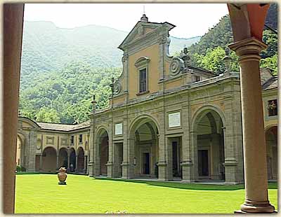
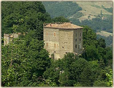
and Monte Tavianella. In the hamlet Baragazza you find the Sanctuary
of Madonna di Bocca di Rio (picture), emerged in the spot where,
as the legend tells, in 1480 on July 16 two shepherds, Cornelia
Evangelisti and Donato Nuttini, saw a miraculous apparition of
the holy virgin, who asked them to build a temple in her honour
in that forest. That's how the legend explains the origin of this
sanctuary, one of the most famous in the Apennines and destination
of pilgrimages from all parts of Italy : in the spot where the
apparition took place a little temple was built, then expanded
at the end of the 16 th cent. and of the 18 th cent. until finally
Venturoli gave it its current form.
|

|
Loiano |
Loiano
Altitude: 713 m above sea level
Town hall: Via Roma, 55 - 40050
Loiano (Bo)
Tel. +39 051 654
36 11 - Fax +39 051 654 52 46
E-mail: comloian@iperbole.bologna.it
Website: http://www2.comune.bologna.it/bologna/comloian
Hamlets: Anconella, Barbarolo, Bibulano, Roncastaldo, Scanello, Scascoli
Short historical description
In the Apennines
south-east of Bologna , following the most beautiful panoramic
road of the region, you arrive in Loiano. The centre is known
in the first place for the Astronomical Observatory of the
University of Bologna . It was built in 1936 and contains
two observation stations, from where you can observe the
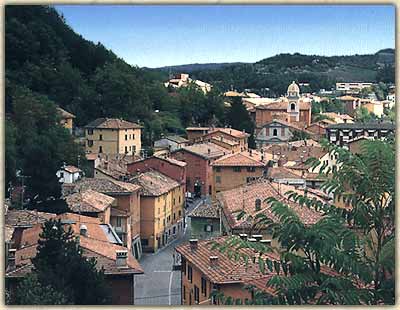
sky with powerful telescopes. In the centre of Loiano (picture)
there are also historical buildings worth a visit. First
of all the Church of San Giacomo and Santa Margherita, from
the 14 th century, built by the Augustinians; the chorus
and the bell tower date back to the 18 th century, the cupola
to 1933. The Church displays two beautiful paintings from the
18 th century: Madonna, Bambino e S. Giacomo by Calvart and Madonna
del Carmine by A. Pio. In 1859 Pope Pius VII stayed at Villa
Loup after meeting Napoleon in Paris . The same year the abolition
of the customs barriers was decided between Tuscany , Romagna,
Modena and Parma . On October 21, 1786 Goethe spent a night
at the hotel Della Corona on his way to Florence , and reported
this event in his book Italian Journey.
Section
Villages and Paths
|

|
Monghidoro |
Monghidoro
Altitude: 841 m above sea level
Town Hall: Via Matteotti, 1 - 40063
Monghidoro (Bo)
Tel. +39 051 655 56 40 - Fax +39 051 655 55
20
Website: http://www.comune.monghidoro.bo.it/
E-mail: segretario@comune.monghidoro.bo.it
Hamlets: Piamaggio, Campeggio,
Frassineta, Vergiano
Short historical description
In
the Apennines south-east of Bologna you find the
village of Monghidoro, formerly called Scaricalasino
(unload the donkey): in this place, being a papal
customs office on the border with Tuscany , people
had to allow the control of the burdens carried by
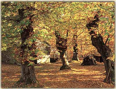
their animals. The region is of great naturalistic
value and full of woods (picture) and picturesque
rural buildings. Catholics might consider the Sanctuary
of Madonna dei Boschi worth a detour. It was built
in 1680 and features an image of the Madonna of San
Luca, which is carried every year in the parish to
allow the parishioners to formulate their requests
to the Holy Virgin. Nearby, in Vergiano, the ancient
Church of San Alessandro is situated, and a group
of houses from the 16 th century.
|

|
Monterenzio |
Monterenzio
Altitude: 200 m above sea level
Town hall: Piazza Guerrino De Giovanni,
1 - 40050 Monterenzio (Bo)
Tel. +39 051 929 002 - Fax +39 051
929 292
Website: http://www.comune.monterenzio.bologna.it/
E-mail: urp@comune.monterenzio.bologna.it
Hamlets: Bisano, S.Benedetto
del Querceto, Sassonero, Rignano Bolognese, Vignale, Sassuno, Pizzano,
Cassano
Short historical description
In the Apennines south-east of Bologna,
passing Mercatale, you reach the village of Monterenzio, that
covers a big area of the Apennines between the valley of the
river Idice and the valley of the river Sillaro. From 1298 on
the records mention the Castle of Monterenzio : it was destroyed
by the troops of Barbarossa and by the war between Bologna and
Ferrara . Then there are no further traces in the local records
from the middle of the 14 th century on, but there is lots of
evidence of the medieval origins of the centre. Between the new
part, Monterenzio Nuovo, and the old one, Monterenzio Vecchio,
rises the 13 th century Tower, the most important place in the
village of Scaruglio , with origin in the 14 th century. Heading
down in the direction of the river Idice you find another village,
Villa di Cassano. Its buildings have origins in the second half
of the 14 th century and the following century. On the massif
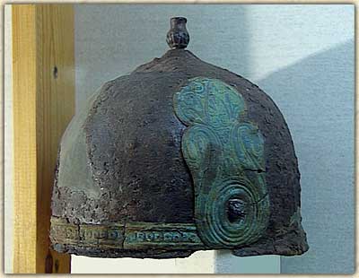
of Monte Bibele, not far from Monterenzio, ruins of an Etruscan-Celtic
village with origin in the 4 th century B.C. have been discovered.
The excavations brought to light graves, buildings, streets and
a lot of objects of daily use, like crockery containing carbonized
seeds, utensils, decorations, arms and coins.
Nowadays these finds
can be seen in the Archaeological Museum Luigi
Fantini in Monterenzio. You also can admire important funerary
equipment from the close necropolis, containing the emblematic
iron helmet with bronze appliqués (picture), Palaeolithic
and Mesolithic tools, fragments of Roman pottery, papers, documents
and photographs that witness the history of the Valley of the
river Idice. |

|
Monzuno |
Monzuno
Altitude: 630 m above sea level
Town Hall: Via Casaglia, 4 -
40036 Monzuno (Bo)
Tel. +39 051
677 33 11 - Fax +39 051 677 01 44
Website: http://www.comune.monzuno.bologna.it/
Email: segretario@comune.monzuno.bologna.it
Hamlets: Vado, Rioveggio
Short historical description
In the Apennines south-east of Bologna,
turning off the road Porrettana onto
the Strada del Setta, after climbing up for about 10 kilometres
you arrive in Monzuno. The name probably comes from Jove (Mons
Zeus) or from Juno (Mons Juno) and it got the rights of an independent
commune in 1803. The populated area you see now is modern, but
has the big advantage of facing a beautiful valley with lots
of interesting historical sights and naturalistic spots worth
a visit. The Church of San Giovanni Evangelista , rebuilt in
1891, has a surprising baroque interior. Nearby, in Bigola, you
find the Church of San Michele from the 14 th century, which
was rebuilt in the 17 th cent. and has a baroque interior as
well; inside you find a portrait of the Saint, a copy of the
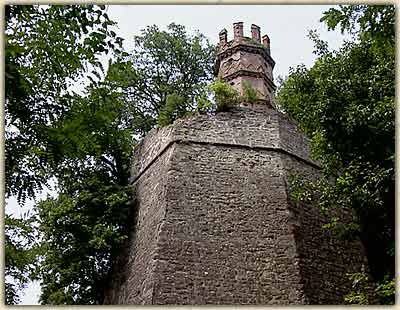
one by Reni kept in Rome . In Rioveggio you can admire the Castle
of Elle , belonging to the Berti family, who possess also two
partly renovated manor-houses: the one of the Polverara and the
Tower of Montorio (picture). Not far away from Monzuno rises
Monte Venere, 996 metres high, where there was once a temple
dedicated to the goddess of love. |

|
Pianoro |
Pianoro
Altitude: 207 m above sea level
Town hall: Piazza dei Martiri, 1
- 40065 Pianoro (Bo)
Tel. +39 051 652 91 11 - Fax +39 051 774
299
Website: http://www.comune.pianoro.bo.it/
Hamlets: Pianoro nuovo, Musiano,
Rastignano, Sesto, Pianoro Vecchio, Livergnano, S.Salvatore di Casola,
Riosto, S.Maria di Zena, Gorgognano, Montecalvo, Montelungo, Guzzano.
Short historical description
In the Apennines south-east of Bologna,
following the road Della
Futa and going through Rastignano you find Pianoro; a kilometre
before the old part Pianoro Vecchia there is the Torre dei Lupari from
the 15 th cent., a building with a tower, a loggia and a fountain
mask. The new centre of Pianoro rises three kilometres after
the ancient one, where you ought to visit the Church of S. Giacomo
Maggiore . It was restored in the 18 th cent. together with a
kind of pilgrim hospital, which has been recorded since the
12 th century. 15 kilometres distant from Pianoro you find the Monte
delle Formiche (Ant Mountain), an isolated mountain that gives
you a beautiful view and that owes its name to a curious natural
phenomenon: around September 8 th , the sacred day of the Madonna,
swarms of flying ants reach the top of the mountain and enter
the church where they finally die. Traditionally these insects
are welcomed, blessed and distributed among the parishioners:
the popular belief says that they cure certain diseases. At the
foot of Monte delle Formiche is situated another interesting
building, the Castle of Zena (picture), built near the river
of the same name. The castle has medieval origins as well. Count
Guido Selvatico di Dovadola was held prisoner in the manor in
1270, after getting caught by the Counts of Loiano and S. Lazzaro,
and afterwards set free by the Bolognese. The Sanctuary of Monte
delle Formiche, also known as S. Maria di Zena, was first built
in the Middle Ages and restored various times, in 1297, in the
18 th and 19 th cent. and in 1955.
|

|
Sasso Marconi |
Sasso Marconi
Altitude: 132 m above sea
level
Town hall: Piazza dei Martiri, 6 - 40037 Sasso Marconi (Bo)
Tel.
+39 051 843 511 - Fax +39 051 675 01 51
Email: lzini@smarconi.provincia.bologna.it
Website: http://www.comune.sassomarconi.bologna.it
Hamlets: Fontana,
Badolo, Battedizzo, Pontecchio, Borgo Nuovo, Tigliano, Capoluogo
Short historical description
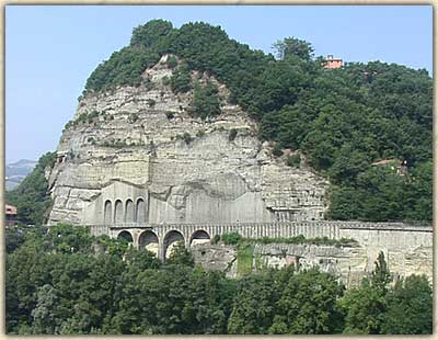
In the Apennines
situated south-east of Bologna you find Sasso
Marconi. It owes its name to the name of a cliff (Sasso) (picture)
that rises not far from the confluence of the rivers Setta and
Reno just above the important road Via Porettana, and to Guglielmo
Marconi. The region contains lots of beautiful villas: Villa
Fontana from the 15 th century, Villa delle Torrette (in front
of which is situated the Oratorium of Santa Apollinia, with two
Latin inscriptions from 1630), and Villa Quiete, which was the
residence of the painter Francesco Albani: on one of the pavements
you still notice a dark patch, perhaps of blood. The story goes
that in the 16 th century a young man, member of the Caprara
family, fell down at that point, lethally injured. The castle Castello
de' Rossi, in Pontecchio, was built between 1482 and 1485: Pope
Julius II was guest there in 1507 and Pope Paul III in 1541,
and also the poet Torquato Tasso stayed there in 1587. Villa
Fontana, also called Palazzo Sanuti, has origins in the 15 th
century, and its courtyard has arcades and a beautiful fountain.
Before entering Sasso Marconi you arrive at the district Pontecchio
situated on the Via Porrettana, with the most important residence
of the area: Villa il Griffone. In the park surrounding the Villa
stands the Mausoleum where the famous scientist Guglielmo Marconi
is buried. The Villa was built by the Griffoni brothers at the
end of the 17 th century, but owes the current face to the Patuzzi
family, who modified it in the 18 th century. The building passed
to the Marconi family in 1895, and it was in these rooms that
Guglielmo Marconi conducted his first experiments on wireless
telegraphy. |

|
S.Benedetto Val di Sambro |
S.Benedetto Val di Sambro
Altitude: 600 m above sea level
Town hall: Via Roma, 39 - 40048 San Benedetto
Val di Sambro (Bo)
Tel. +39 0534 95 026 - Fax +39 0534 95 595
Website: http://www.sambro.provincia.bo.it/
Email: Segretario@comune.sanbenedettovaldisambro.bo.it
Hamlets:
Madonna dei fornelli, Castel dell'Alpi, Pian del Voglio, Montefredente,
S.Andrea, Monte Acuto Vallese, Ripoli, Pian di Balestra, Cedrecchia,
Zaccanesca, Qualto
Short historical description
In the Apennines south-east of Bologna you find San Benedetto
Val di Sambro, originated due to the amalgamation of the villages
of Pian del Voglio and Poggio dei Rossi, both having origins
in ancient times. In Pian del Voglio you should visit the Palazzo
Comitale with a 15 th century tower. It is situated next to the
Church of San Giovanni Battista and was owned by the dominating
family of the place, De' Bianchi, had the Medici as guests during
their exile from Florence and was also the residence of the Cardinal
Lambertini, before he was elected as Pope Benedict XIV. In Ripoli
you find the Church of Sant'Andrea . Its existence back to the
14 th century is proved, and it was rebuilt at the end of the
17 th cent. Inside you can admire the painting of the Visitation
of Madonna, supposed to be painted by Guido Reni. The small village
of Madonna dei Fornelli owes its name to a pilgrimage church
dedicated to Madonna della Neve, built in 1638 by the population
in order to celebrate the end of the plague. You can see the
image of the Holy Maria with Child on copper in the small temple,
which was extended at the end of the 19 th cent. and at the beginning
of the 20 th cent.
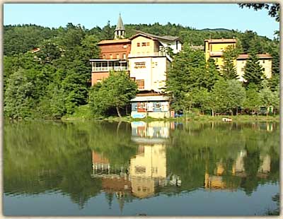
Another excellent destination for a little tour is Castel dell'Alpi
on the edge of the lake with the same name (picture), seven kilometres
from San Benedetto: In 1951 a mudflow blocked the flow of the
river Savena and gave birth to this lovely artificial lake, where
you can sunbathe and have nice picnics on its shore. |
|